Weather patterns are ever changing, but they aren’t just fluctuating. Technical weather tools are becoming more
widely available for public use and have been rapidly improving over recent
decades. Practically the entire weather
enterprise has been transforming their ways of doing business. Not only are the numerical models that help generate
many weather forecasts getting better, but they are also gathering data, being
run, verified, and printed in new innovative ways. Some data from those early years of numerical
weather prediction implementations can now be compared with today’s weather
patterns less than a century after the first successful numerical weather
forecast.
Atmospheric scientists recently began incorporating historical
weather analog years as new tools to better forecast and verify medium and
longer range weather patterns. NASA’s Goddard Institute for
Space Studies and NOAA’s Earth System
Research Laboratory’s Physical Science Division have both produced mapping
websites for anyone who wants to run a model that can produce analogs to be
compared to similar atmospheric parameters of the current weather patterns
around the world. Maps for this blog
post were generated from NASA and subjectively selected by comparing them to regional
surface temperatures from this past November dating back as far as the early 1920s.
Some background to
the 2015-2016 winter anticipation and the significance of analogs in
forecasting it
November and December were mild in record fashion in the
Eastern United States near the end of 2015.
There were multiple interesting signals from several sources for several
months being tossed around the web since early summer 2015 that the upcoming winter had
the potential to be another active one. When
you look at the last couple winter seasons around Washington, D.C., you would
want to think; how can a third consecutive winter with above average seasonal snowfall
be expected? That would be quite a record
for the Nation’s Capital!

Surface temperature
map from NASA’s Goddard Institute for Space Studies for November 2015
Conditions as of November 2015 continue to show one of the
warmest periods on record across the tropical Pacific that can be seen in the NASA
analog map. Why would a warm Pacific Ocean lead to
snowstorms along the U.S. eastern seaboard when the last time the Pacific sea
temperatures were this warm back in the 1997-1998 winter there was very little
snow at all in the eastern United States? The answer may lie in the placement of the
warmest ocean water. This is where the commonly
referred to El Nino Southern Oscillation (ENSO) comes into play. Strongly positive ENSO events tend towards
having the warmest waters closer to the South American coastline. The November 1997 analog map is a prime
example of an east based ENSO event and was also the strongest on record! ENSO values for 2015 were similar to 1997,
but one major difference is the proximity of the warmest pacific waters. This year there are indications that the
warmest sea temperatures may gradually shift more toward the Central Pacific. What does this do? It shifts regional weather patterns! 1997 was just one of several analogs that
were selected for the 2015-2016 winter.
The maps below highlight areas of some similar regional
temperature patterns that closely relate to this past November. The similarities of the ENSO region across
the tropical Pacific were chosen as a baseline for each of the selected analog
years. Each analog year had different
weather across the globe, but some years show pattern links for only particular
regions. Above average snow seasons for Washington,
D.C. among these chosen analogs included 1905, 1957, 1965, 1982, 2002, and 2009. None of these comparisons will have a perfect
fit correlation, but some signals may be common for high snowfall positive ENSO
analog years. Black rings highlight regions
that closely match the November 2015 map from earlier. It’s interesting to see that the ranks for the
higher seasonal snowfalls somewhat resemble the ranks of highest to lowest
snowfall seasons seen in the table below.
November 1965 was an anomaly in that sense and it would be interesting
to learn why that year was so different around the globe with relatively colder
global anomalies during such a moderately positive ENSO year.
Year
|
D.C. Seasonal Snowfall
|
Number of Similar Regions
|
2009
|
56.1”
|
7
|
1957
|
40.4”
|
7
|
2002
|
40.4”
|
7
|
1965
|
28.4”
|
2
|
1982
|
27.6”
|
5
|
1905
|
25.7”
|
4
|
1994
|
10.1”
|
5
|
2006
|
9.5”
|
5
|
1902
|
8.2”
|
5
|


Winter 2016 verification

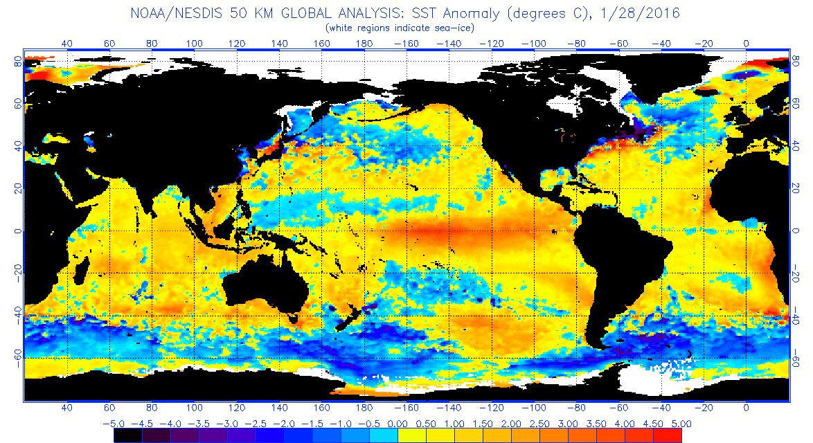
As of January 28, 2016 the warmest tropical Pacific sea surface temperatures have progressed westward toward the central tropical Pacific as anticipated and Washington D.C. now has above average snowfall for 2016 following a historic blizzard that was successfully forecast a week in advance. Global sea temperatures remain anomalously high, although seasonal models have been hinting that a rather abrupt turnaround may happen later in 2016 toward more of a negative ENSO signal (La Nina). Conditions throughout much of the Pacific Basin have already cooled somewhat since the positive ENSO peak that occurred during late 2015 and that trend will likely continue as seen in the ensemble chart from Columbia University’s International Research Institute for Climate and Society.

ENSO Ensemble Plumes
for Mid-January 2016 from Columbia University’s International Research
Institute for Climate and Society.