Tuesday, December 6, 2022

Expect Higher Uncertainty for Weather Forecasts At Least Over the Next Couple Weeks

There are multiple reasons why the upcoming pattern may exhibit higher uncertainty than usual beyond a couple days. 

This year is another la nina winter, when tropical pacific ocean temperatures are below average along the South American coast.  During la nina winters, the jet stream tends to have higher amplitude waves.  This creates a tendency for frequent back-and-forth weather between unseasonable warm days and more typical winter weather for this time of year. 


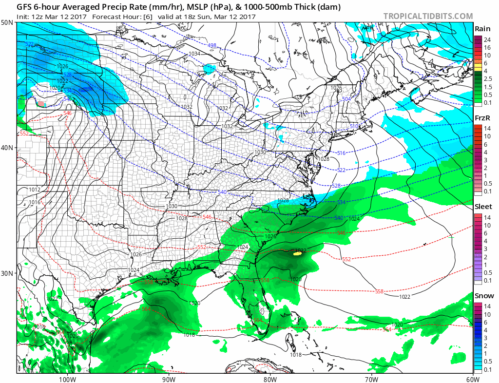
 The current pattern has a large North Atlantic blocking event that has formed high pressure over Greenland with unusually high temperatures for that region.  Often times when there is such a strong blocking event, winter storms develop and track across the United States, but that hasn't occurred.  One likely explanation for this is the Pacific Coast has a deep trough while the Greenland block is in place.  Meteorologists measure the strength of North Atlantic blocking by the NAO (North Atlantic Oscillation).  The NAO correlates atmospheric and oceanic conditions relative to the atmospheric pressure near Greenland.  The more negative the NAO falls, the stronger the blocking.  Multiple weather models are forecasting the current negative NAO to recover back towards 0.  Forecasts will likely be more uncertain in coming days, because the more neutral NAO tendency prevents a clear signal in correlating the NAO to the upcoming weather pattern.  


 https://www.cpc.ncep.noaa.gov/products/precip/CWlink/pna/nao.shtml


A more modern and less widely used forecasting technique uses the Madden Julian Oscillation (MJO).  "The Madden-Julian Oscillation (MJO) is a tropical disturbance that propagates eastward around the global tropics with a cycle on the order of 30-60 days." 

https://www.cpc.ncep.noaa.gov/products/precip/CWlink/MJO/MJO_1page_factsheet.pdf

The location of the MJO is tracked across the tropical oceans in 8 phases.  Each phase signals a certain weather pattern regionally across the globe.  Charts have been created to show the most likely temperature and precipitation patterns for each MJO phase for each month of the year.  During much of the winter, MJO phases 8,1, and 2 have the best chance for cold temperatures in the Eastern U.S.  https://www.cpc.ncep.noaa.gov/products/precip/CWlink/MJO/Composites/Temperature/

The MJO does not currently favor a particular phase number.  Because of this, there is no clear signal for the upcoming weather pattern. 

https://www.cpc.ncep.noaa.gov/products/precip/CWlink/MJO/combphase_noCFSsmall.gif

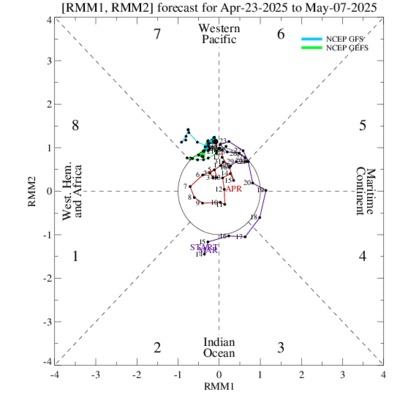
 In order for the MJO to be used as a forecasting tool, the colored lines would have to propagate toward one of the phases.  The current conditions are neutral with no clear phase being modeled in the forecast period. 


Friday, October 4, 2019

BTRWx's 2019-2020 Winter Outlook Analyses

DISCLAIMER: Not everything from this blog post is sound factual science.  These are my own thoughts about recent seasonal forecasting trends.  I'm not a meteorologist, but I have a meteorology-equivalent degree and would like to pursue the career field.


The data is becoming clearer about what the upcoming winter may bring.  I have compiled three analog years that I believe have similar implications for this upcoming winter season.  They are 2004-2005, 2014-2015, and 2018-2019.  I chose these years by comparing late summer global sea surface temperatures (ssts) to this year (2019).  The sea surface temperature data was plotted from NASA's GISS Surface Temperature Analysis (v4).  Atmospheric data was plotted using NOAA's Earth System Research Laboratory's Reanalysis data.  


Global mean ssts were above average for each analog year during August.  Particularly, the Pacific Northwest waters were much above average for the listed analog years.  This region can play an important role for foreshadowing what weather may occur farther east toward the Mid Atlantic, the region of focus for this blog.  What typically happens is a ridge commonly forms over the area of warmer ssts and the jetstream rounds the ridge anti-cyclonicly (clockwise).  A downstream trough forms between the central U.S. and Midwest states and the jetstream rounds the axis to the south cyclonicly (counter-clockwise) towards the Mid Atlantic.  This is how the Mid Atlantic often experiences stormy weather and favorable winter storm tracks.  If ssts look like this during winter, I'll be more excited.  But we're still a couple months away from winter, so the ssts will likely change.

The tropical eastern Pacific shows near neutral sst anomalies for each analog year.  This region is arguably the most important area for seasonal forecasting, but because the ssts are near normal, there is no strong signal.  There's generally a warm northern Atlantic Basin and near normal equatorial Atlantic among the analogs and below normal ssts just north of Australia.  These consistencies were notable for why I chose the three noted analog years.  


Knowing previously mentioned analysis, I plotted the analog years into user-defined map criteria.  Atmospheric conditions from December to February generally show above normal heights signifying potentially slightly above normal temperatures for much of the winter.  The lower heights over the Arctic (blue shading) are not a good sign for favorable winter conditions over the eastern U.S.  We want to see the opposite of that, and we especially want higher heights over central Greenland.  Early indications would show winter 2019-2020 as not great, but not horrible either.  


Digging deeper into each month, a few pattern trends stand out to me.  February appears to show the the best chances for below normal temperatures while the warmest month would be December.  January looks to be near normal.  D.C. averages 15.4" total seasonal snowfall annually and I expect 2019-2020 to be very close to average snowfall.  I would lean slightly above average temperatures overall with the coldest part of winter being late February and likely into March. 

Sunday, March 12, 2017

Cataloging fine print details of historic snowfall expected twenty four years after one of the most infamous winter storms on record


DISCLAIMER: The following discussion describes recent atmospheric trends and how they may interrelate to a past historical event.  *This is not a forecast* The model data trends being shared are used for amateur interpolations.

Today marks the ides of the 24th anniversary of some of March's greatest weather impacts on record.  Now we're not expecting the intensity from that monster storm, but the current evolution of the upper atmosphere from operational weather models do appear to somewhat resemble the evolution.  

Two areas of atmospheric energy are modeled to interact and eventually phase over the Atlantic Ocean.  One piece of the northern polar jet stream is modeled to dive south from out of the Pacific Northwest and Northern Great Plains while a small system from the subtropical jet stream initially over Mexico develops over the warm Gulf of Mexico.  The two jet streams are modeled to eventually interact and develop a phased storm system off the East coast of the U.S.

Afternoon European ensemble model upper atmosphere simulation from TropicalTidBits.com
 

The March 1993 storm of last century experienced some of the lowest atmospheric pressure levels for several cities and became one of the strongest winter storms on record.  It's highly unlikely that March 14, 2017 will produce a storm of such extreme intensity, but some of the threatening weather from that day 24 years ago should be anticipated.  

Here is an animation of what the atmospheric flow from March 1993 produced from an excellent NOAA report of the storm

SNOWFALL

The weather models have been having difficulties with how the rain/snow line orientation will shift during the storm tomorrow night into Tuesday March 12, 2017.  The D.C. metro areas could be at risk for precipitation briefly switching from snow to sleet and possibly rain for a time.  In such a scenario localized snowfall would not be as deep.  A changeover to mixed precipitation has happened before with big D.C. area snow storms, so it's not all that uncommon to see.
  
The animation below shows a simulation of precipitation from the afternoon run of the high resolution 3 kilometer Nest North American Model (3km NAM) from TropicalTidBits.com

 
Here is a similar simulation from the Global Forecast System (GFS) Model from TropicalTidBits.com
  

Here is what the Global Forecast System (GFS) Model has been trending towards over the last 24 hours in terms of snowfall from TropicalTidBits.com.  
Notice the trend similarities!


Storm Placement and Track
 The following animation of images were compiled from weather model data sites TropicalTidBits.com and NOAA's NCEP data server showing sea level pressure and precipitation snapshot trends off the Virginia coastline. 


Meteorologists amateur and pro now know the March 1993 storm by name.  It deepened explosively along its journey over the Eastern seaboard and left behind some of the most remarkable textbook satellite imagery as such from Wikimedia commons.

https://upload.wikimedia.org/wikipedia/commons/9/9c/Storm_of_the_century_satellite.gif

The models all unanimously show a high impact winter storm that will be riding up the coast with heavy snows from parts of Virginia to Maine over the next couple days.  This one will likely not be quite as bad as 1993, but uncertainty in model trends are still unusually high just a day prior to the storm's development.  Stay tuned to your local forecasts at www.weather.gov/(enter zip code)