There are multiple reasons why the upcoming pattern may exhibit higher uncertainty than usual beyond a couple days.
This year is another la nina winter, when tropical pacific ocean temperatures are below average along the South American coast. During la nina winters, the jet stream tends to have higher amplitude waves. This creates a tendency for frequent back-and-forth weather between unseasonable warm days and more typical winter weather for this time of year.

The current pattern has a large North Atlantic blocking event that has formed high pressure over Greenland with unusually high temperatures for that region. Often times when there is such a strong blocking event, winter storms develop and track across the United States, but that hasn't occurred. One likely explanation for this is the Pacific Coast has a deep trough while the Greenland block is in place. Meteorologists measure the strength of North Atlantic blocking by the NAO (North Atlantic Oscillation). The NAO correlates atmospheric and oceanic conditions relative to the atmospheric pressure near Greenland. The more negative the NAO falls, the stronger the blocking. Multiple weather models are forecasting the current negative NAO to recover back towards 0. Forecasts will likely be more uncertain in coming days, because the more neutral NAO tendency prevents a clear signal in correlating the NAO to the upcoming weather pattern.
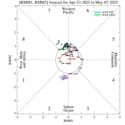
A more modern and less widely used forecasting technique uses the Madden Julian Oscillation (MJO). "The Madden-Julian Oscillation (MJO) is a tropical disturbance that propagates eastward around the global tropics with a cycle on the order of 30-60 days."
https://www.cpc.ncep.noaa.gov/products/precip/CWlink/MJO/MJO_1page_factsheet.pdf
The location of the MJO is tracked across the tropical oceans in 8 phases. Each phase signals a certain weather pattern regionally across the globe. Charts have been created to show the most likely temperature and precipitation patterns for each MJO phase for each month of the year. During much of the winter, MJO phases 8,1, and 2 have the best chance for cold temperatures in the Eastern U.S. https://www.cpc.ncep.noaa.gov/products/precip/CWlink/MJO/Composites/Temperature/
The MJO does not currently favor a particular phase number. Because of this, there is no clear signal for the upcoming weather pattern.

In order for the MJO to be used as a forecasting tool, the colored lines would have to propagate toward one of the phases. The current conditions are neutral with no clear phase being modeled in the forecast period.
No comments:
Post a Comment